Inspection
Thermal Imaging Drone Pilots
Thermal imaging records the infrared a surface emits rather than the light it reflects, producing an image of relative surface temperature. It is used on building fabric, on solar arrays and on land, and the conditions each needs differ sharply. What a temperature pattern means is an interpretation rather than a reading.
What this service involves
Thermal imaging captures the infrared radiation a surface emits rather than the light it reflects, producing an image of relative surface temperature. Flown from a drone, it covers roofs, facades, arrays and land quickly and without access equipment.
A thermal sensor is a different instrument from a normal camera, not a mode on one. The imagery it produces shows temperature differences, and turning those differences into a conclusion about moisture, insulation or a failed component is an interpretation that needs training. The image on its own shows a pattern, not a fault.
Who hires drone pilots for this, and why
- Building owners and managing agents investigating heat loss, damp or a flat roof that is holding water somewhere nobody can see.
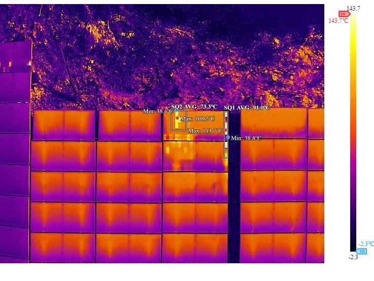
- Solar operators and installers, checking arrays for cells and strings that are running hot, which is visible thermally long before it is visible any other way.
- Facilities and maintenance teams surveying electrical and mechanical plant for components running outside their normal range.
- Agricultural and environmental users, looking at irrigation, crop stress and water across areas too large to inspect on foot.
What to expect on the day
Timing matters more here than in any other kind of drone work, and it is not about light. It also depends entirely on what is being surveyed, because the two main kinds of thermal work want opposite conditions.
Building fabric work looks for heat moving through a structure, so it needs a temperature difference across the envelope and a surface the sun is not loading. Those surveys are commonly flown at night or shortly before dawn, after a surface has had hours to release the heat it absorbed during the day, and the international standard for infrared examination of buildings sets conditions of that kind. A building survey flown in direct midday sun can show almost nothing useful.
Solar array work is the opposite case and is described on its own page. A module only runs warm while it is generating, so an array is inspected in bright conditions while it is working, not at night. Anyone quoting for thermal work should say which of the two they are flying, because the right time of day for one is the wrong time for the other.
Recent rain, standing water, wind and direct sun all change what the sensor reads, so a thermal survey has more conditions attached to its date than a visual one.
Delivery is usually a set of radiometric images, which retain the temperature data per pixel rather than only the colours, together with matching visual images so a pattern can be located on the actual structure. Interpretation is separate work and is normally quoted separately.
Thermal Imaging: frequently asked questions
Does a thermal image show damp directly?
No. It shows surface temperature differences. Water changes how a surface holds and releases heat, so damp often produces a distinctive pattern, but reading that pattern as damp rather than as shading, airflow or a construction difference is an interpretation.
Why are building thermal surveys flown at night?
Because a building survey needs a temperature difference across the structure to see. After a day of solar gain, materials release heat at different rates depending on what is behind them, and that difference is what the image shows. Flown in direct sun, the sun dominates and the detail is lost. This applies to building fabric rather than to thermal work generally: a solar array is the opposite case and is inspected in bright conditions while it is generating.
Is this the same equipment as a normal drone camera?
It is a separate sensor. Some aircraft carry both a thermal and a visual camera and record them together, which is useful because a thermal image on its own can be hard to locate on the building it came from.
What is a radiometric image?
One that stores a temperature value for every pixel rather than only a colour. It allows a specific point to be measured afterwards rather than estimated from the palette, and it is what makes the imagery useful as evidence later.
Can it inspect a solar array while it is generating?
That is the normal way to do it. A cell or string that is underperforming dissipates energy as heat, so the fault is visible thermally while the array is under load and effectively invisible when it is not.
Drone pilots offering Thermal Imaging
Other drone services
Aerial PhotographyReal Estate PhotographyProperty Flythrough360 Video & PhotographyAerial VideographyFPV (First Person View)Roof InspectionBridge InspectionFacade SurveySolar Panel InspectionInfrastructure & Utilities InspectionLand SurveyTopographical SurveyVolumetric SurveyPhotogrammetryRoad SurveyLiDAR SurveyAgricultural SurveyCoastal SurveyEstate SurveyConstruction MonitoringEvent CoverageWedding VideographyFilm & TV ProductionCinematographyLive StreamingTourism & TravelStock Footage
Browse the full drone pilot directory or explore drone services by location.